


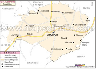
Ghazipur district is situated in eastern part of Uttar Pradesh. The total area of the district is 3377 sq km with total population of 30.37 lakh with density of population as 899 persons per sq km. The district has 16 blocks viz. Zakhniya, Manihari, Sadat Saidpur, Devkali, Virnao, Mardh, Ghazipur, Karanda, Kasimabad, Varachavar, Mohammadabad, Bhavarkol, Jamania, Reotipur and Bhadaura. The district has 3364 villages and there are three rivers in the district viz. Ganga, Gomti and Karmnara. The net sown area is 2.54 lakh ha with the cropping intensity of 161.45%. Including the seasons of kharif, rabi and zaid, a total area of 4.36 lakh ha is put under various crops such as wheat, rice, pulses, sugarcane and oilseeds, potato, vegetables, onion, tomato, chilli and banana etc. The district has a large number of cold storages spread in five blocks of the district that provide easy access to farmers for storing potato.
�
�
�
�
�
| � | � |
|---|---|
| Geographical Area | 333.214 |
| Cultivable Area | 254.711 |
| Forest Area | 0.121 |
| Land Under Non-Ag Use | 48.667 |
| Permanent Postures | 0.803 |
| Cultivable Waste Land | 3.539 |
| Land Under Misc. Tree Crops and Grover | 3.382 |
| Barren and Uncultivable Land | 3.015 |
| Current Fallows | 15.341 |
| Others Fallows | 3.635 |
| S.N.Particulars | Area (000ha) | |
|---|---|---|
| Net Sown Area | 254.711 | |
| Area Sown more than Once | 157.023 | |
| Gross Cropped Area | 411.734 | |
| Net Irrigated Area | 218.402 | |
| Gross Irrigated | 350.281 | |
| Rainfed | 36.309 | |
| Category of land holding | Total no of farm/house hold | |
|---|---|---|
| Marginal | 331320 | |
| Small | 43369 | |
| Medium & Large | 23071 | |
| Total | 397787 | |
| Average Land Holding | 0.7 | |
| � | � | |
Cropping Intensity: 161.45 %
�| S.N. | Crop | Area (ha) | Productivity(q/ha) |
|---|---|---|---|
| 1 | Paddy | 151.654 | 21.62 |
| 2 | Wheat | 169.658 | 24.27 |
| 3 | Maize | 753 | 14.04 |
| 4 | Jowar | 2.785 | 14.74 |
| 5 | Bajra | 131.89 | 14.16 |
| 6 | Urd | 610 | 8.6 |
| 7 | Moong | 260 | 1.99 |
| 8 | Arhar | 41950 | 10.14 |
| 9 | Groundnut | 200 | 5.98 |
| 10 | Til | 200 | 1.54 |
| 11 | Barley | 71043 | 1665 |
| 12 | Gram | 21680 | 864 |
| 13 | Pea | 71849 | 1069 |
| 14 | Masoor | 101848 | 0.905 |
| 15 | Mustard | 0.01392 | 1031 |
| 16 | Alsi | 100 | 4.00 |
| 17 | Sugarcane | 71422 | 45523 |
| S.N.Particulars | Area (000ha) | |
|---|---|---|
| Canal | 50.465 | |
| Tanks | - | |
| Borewells | 167.937 | |
| � | � | |
|---|---|---|
| No of Blocks | 16 | |
| No of Village | 3364 | |
| Gram Panchayat | 1050 | |
| Total Population | 30.3758 lakh | |
| No of Revenue Village | 2665 | |
| � | � | |
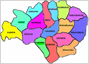
Based upon soil type, soil depth, soil topography and variability of canal irrigation, Ghazipur district has been divided into three major agro-ecological situations. There are a total 16 blocks in Ghazipur district. The details about the type of agro-ecological situation and its characteristics.
This situation is in western south part of district including Saidpur, Sadar, Karanda, Manihari and Deokali having only 29.28% of geographical area.
This situation is observed in the northern part of district including Sadat, Jakhania, Birno, Mardah and Kasimabad block having only 29.99% of geographical area.
This situation is spread over Zamania, Rewatipur, Mohammadabad, Barachawar, Bhawarkol and Bhadaura blick situated in eastern part of the district. The soils in this situation are predominantly low land. Major area of Karail is under Massor, Gram and vegetables.
�Soil Type : Clay Loam, Sandy Loam, Diara Soil (Silt), Balck Soil (Karail Soil)
�(i) Plain alluvial, very deep soil having 0-1% slope, loam to silt loam soiltexture slightly eroded soil: This situation is in the western-south part of the district including Saidpur, Sadar, Karanda, Manihari and Deokali having only 29.28% of the geographical area. The details of this situation are described under agroclimatic zones.
(ii) Plain alluvial, slightly saline and alkali loam to silt loam, 0.1% slightly eroded soil and imperfectly drained soil because calciumcarbonate �Kankar� pan: This situation is observed in the northern part of district including Sadat, Jakhania, Birno, Mardah and Kasimabad block having only 29.99% of geographical area.
(iii) Karail Soil: This situation is spread Zamania, Rewatipur, Mohammadabad, Barachawar and Bhadaura block situated in eastern part of the district. The soil in this situation are predominated low land, major area of Karail is under lentil, gram and vegetables.
�| S.N. | Description | Block Covered |
|---|---|---|
| 1 | Plain, alluvial soil 0-1%, slope, very deep loam to silt loam soil: soil texture, slightly eroded soil, medium rainfall, tubewell, canal irrigation | Sadar, Karanda, Saidpur, Deokali, Manihari |
| 2 | Plain alluvial soil, slightly saline alkali soil, loam to silt loam sil, 0-1% slope, slightly eroded soil, medium rainfall, tubewell and canal irrigation | Birno, Sadat, Mardah, Kasimabad and Jakhania |
| 3 | Water logged karail very deel clay loam to silty clay loam, 1-3% slope, medium rainfall, canal tubewell irrigation, slightly eroded irrigation | Bhawarkol, Mohammadabad, Barachawar, Bhadaura, Jamania and Rewatipur |
Topography : Rice-Wheat cropping system is pre-dominated; temperature varies from 4 to 46.6 degree C maximum from winter to summer. Annual precipitation varies from 800mm to 1034 mm. Paddy crop suffer when October month of Hathia nakshatra. This failure also affects the succeeding Rabi crops and cropping system. Major crops are paddy, maize, pigeon pea, jowar and Bajra in Kharif season wheat, barley, lentil, toria, mustard, field pea and winter vegetables in Rabi season.
Land use Pattern : About 99.06% of total geographical area is cultivable out of total area is 76.3 per cent is net sown area, 0.2% is grass land, 0.9% is uncultivable fallow land, 1.1% is fellow land, 4.7% is current fallow area, 1.0% area of under trees and bushes, remaining 14.6% area is under non agricultural use.
�| S.N. | Categories of Land Holding | Total No of Land Holds |
|---|---|---|
| 1 | Marginal holdings | 331320 |
| 2 | Small Holdings | 43369 |
| 3 | Medium and Large Holdings | 23071 |
| � | Total | 397787 |
| � | Average Land Holding | 0.693 = 0.7 |
| S.N. | Name of Block | Geographical Area | Cultivated Land | Cultivable Waste | Current Fallows | Forest (Reserves) | Forest (open) | Posture | Land Put to Non - Ag Use | Land Under Misc. Plantation | Barren and Uncultivable Land (Waste Land) |
|---|---|---|---|---|---|---|---|---|---|---|---|
| 1 | Jakhania | 20377 | 15438 | 436 | 975 | � | 278 | 90 | 2724 | 107 | 136 |
| 2 | Manihari | 22544 | 17007 | 492 | 1032 | � | 345 | 125 | 2926 | 148 | 210 |
| 3 | Sadat | 22389 | 16129 | 518 | 1757 | � | 409 | 191 | 2822 | 101 | 238 |
| 4 | Saidpur | 21778 | 15770 | 318 | 1473 | � | 279 | 118 | 3236 | 178 | 286 |
| 5 | Deokali | 21999 | 16495 | 222 | 1132 | � | 236 | 62 | 3119 | 136 | 264 |
| 6 | Birno | 15477 | 12741 | 157 | 626 | � | 144 | 39 | 1452 | 86 | 151 |
| 7 | Mardah | 18672 | 14712 | 387 | 831 | � | 289 | 72 | 1911 | 111 | 232 |
| 8 | Ghazipur | 15660 | 11136 | 170 | 503 | � | 131 | 6 | 3101 | 131 | 157 |
| 9 | Karanda | 15561 | 11449 | 119 | 649 | � | 376 | 5 | 2423 | 175 | 121 |
| 10 | Kasimabad | 23034 | 18196 | 231 | 893 | � | 325 | 40 | 2543 | 301 | 377 |
| 11 | Barachawar | 19901 | 18328 | 115 | 467 | � | 152 | 46 | 9094 | 403 | 174 |
| 12 | Mohammadabad | 17349 | 14148 | 104 | 442 | � | 169 | 4 | 2006 | 222 | 133 |
| 13 | Bhawarkole | 25114 | 19659 | 36 | 1609 | � | 195 | 0 | 3874 | 371 | 177 |
| 14 | Zamania | 27074 | 20549 | 146 | 763 | � | 587 | 5 | 4128 | 210 | 81 |
| 15 | Rewatipur | 22590 | 17240 | 92 | 1229 | � | 289 | 1 | 3348 | 248 | 87 |
| 16 | Bhadaura | 20557 | 15250 | 267 | 969 | � | 56 | 3 | 3125 | 367 | 405 |
92 per cent of the land holdings are dominated by small and marginal farmers
| S.N. | Block | Total Holdings | Large (Nos) | Area | Small (Nos) | Area | Marginal (Nos) | Area | Landless (Nos) |
|---|---|---|---|---|---|---|---|---|---|
| 1 | Jakhania | 27454 | 369 | 1080 | 7963 | 8312 | 18022 | 6046 | 1101 |
| 2 | Manihari | 28985 | 290 | 586 | 8985 | 10167 | 18840 | 4254 | 870 |
| 3 | Sadat | 27692 | 277 | 558 | 9062 | 10763 | 17446 | 4808 | 907 |
| 4 | Saidpur | 25491 | 257 | 524 | 8133 | 9074 | 16314 | 6172 | 785 |
| 5 | Deokali | 29042 | 261 | 532 | 9522 | 10302 | 18442 | 5661 | 817 |
| 6 | Birno | 18812 | 175 | 562 | 5740 | 5877 | 12171 | 6502 | 726 |
| 7 | Mardah | 20117 | 203 | 411 | 6069 | 6582 | 13935 | 7719 | 910 |
| 8 | Ghazipur | 18015 | 187 | 387 | 5705 | 7184 | 11061 | 3565 | 1062 |
| 9 | Karanda | 13826 | 145 | 293 | 4131 | 6920 | 8918 | 4236 | 632 |
| 10 | Kasimabad | 24389 | 243 | 507 | 6722 | 10611 | 15877 | 7078 | 1547 |
| 11 | Barachawar | 16988 | 167 | 349 | 4762 | 9775 | 10906 | 6204 | 1153 |
| 12 | Mohammadabad | 18840 | 217 | 477 | 6230 | 8012 | 11850 | 5609 | 543 |
| 13 | Bhawarkole | 15196 | 169 | 373 | 4514 | 10833 | 9862 | 8453 | 651 |
| 14 | Zamania | 18722 | 87 | 212 | 5733 | 10844 | 12350 | 9493 | 632 |
| 15 | Rewatipur | 11977 | 63 | 152 | 3552 | 6606 | 8605 | 10482 | 747 |
| 16 | Bhadaura | 12638 | 93 | 207 | 3143 | 6898 | 4867 | 8145 | 935 |
However, the soils in Ghazipur, Jaunpur, Varanasi, Deorai and Gorakhpur districts rated low in organic matter, low in available nitrogen, low in available phosphorus and medium in potassium, low in Zn status with the increasing population pressure on agriculture has been increased tremendously. To increase production more and more chemical fertilizer, chemical pesticides were used that adversely affected not only environment but the soil health also. In Ghazipur district 214207ha land is under irrigation, normally is common areas farmers preferred rice cultivation continuously same land. The soil analysis report of the samples analyzed by the district soil survey and soil testing laboratory Ghazipur indicated more than 70% samples are deficient in organic carbon and 80% of samples are deficient in phosphrous. On the basis of samples analyzed during the year 2008-13 indicated 99% of the soil samples ranges between pH 6.5-8.5 and electrical conductivity of 95%. Sample ranges 0-1 improvement in soil health through exclusion of green manure, legume crops, vermi-compost, compost, farm yard manure, bio-fertlizer and crop rotation, soil type clay loam, sandy loam, diera soil (silt), black soil (Karail region). Agricultural innovation partnership the continuity of paddy-wheat crop rotation and including pulses to improve soil health through nitrogen fixation. Chronic arsen poisoing can cause serious health problem in animal including human such as soil and water samples taken from eastern district of Ballia and Ghazipur of Uttar Pradesh.
Soil health is a state of soil meeting its range of ecosystem function a appropriate to its environment. Soil is the foundation of any farming system. Having healthy soil in essential for growing healthy crops and feeding a healthy diet to livestock and people, Soil health is the condition of soil in a defined space and at a defined scale relative to a described bench mark. The definition of soil health may vary between users of the term as alternative users may place different priorities upon the multiple function of a soil. Therefore, the term soil health can only be understood within the context of the use of term and their aspirations of soil as well as by the boundary definition of the soil at issue.
�Organic farming is a form of agriculture that relies on technique such as crop rotation, green manure, compost and biological pest control. Depending on whose definition is used. Organic farming uses fertilizer and pesticides (Which include herbicide, insecticide and fungicides). Organic farming uses a variety of methods to improve soil fertility including crop rotation, cover cropping, reduced tillage and application of compost.
�Organic farming is a form of agriculture that relies on technique such as crop rotation, green manure, compost and biological pest control. Depending on whose definition is used. Organic farming uses fertilizer and pesticides (Which include herbicide, insecticide and fungicides). Organic farming uses a variety of methods to improve soil fertility including crop rotation, cover cropping, reduced tillage and application of compost.
�| S.N. | Problem Soil | Area in ha | Extent of Severity |
|---|---|---|---|
| 1 | Saline Soil | - | Very Severe : - Severe : - Mild : - |
| 2 | Alkaline Soil | 2993 | Very Severe : - Severe : - Mild : - |
| 3 | Acidic | - | Very Severe : - Severe : - Mild : - |
| 4 | Soil Erosion | 9842 | Very Severe : - Severe : - Mild : - |
| 5 | Iron Toxicity | - | Very Severe : - Severe : - Mild : - |
| 6 | Micro - Nutrient Deficiency | 87347 | Very Severe : - Severe : - Mild : - |
| 7 | Water Logged Condition | 9663 | Very Severe : - Severe : - Mild : - |
| 8 | Other Barrend Land / Waste Land | 1257 | Very Severe : - Severe : - Mild : - |
| S.N. | Block | Loam | Silt Loam | Silt Clay Loam |
|---|---|---|---|---|
| 1 | Jakhania | Area : 3353 % :21.72 |
Area : 10212 % :66.14 |
Area : 1677 % :10.86 |
| 2 | Manihari | Area : 4559 % : 27 |
Area : 11313 % :67 |
Area : 797 % : 4.72 |
| 3 | Sadat | Area : 5387 % : 33 |
Area : 9631 % : 59 |
Area : 1073 % : 6.57 |
| 4 | Saidpur | Area : 10957 % : 69 |
Area : 1116 % : 7 |
Area : % : |
| 5 | Deokali | Area :5714 % : 34 |
Area :8186 % : 48.71 |
Area :1015 % : 6.04 |
| 6 | Birno | Area : 2898 % : 23 |
Area : 7182 % : 57 |
Area : 117 % : 00.93 |
| 7 | Mardah | Area : 2501 % : 17 |
Area : 8974 % : 61 |
Area : 3119 % : 21.20 |
| 8 | Ghazipur | Area : 8129 % : 73 |
Area : 2693 % : 24.18 |
Area : % : |
| 9 | Karanda | Area : 4236 % : 37 |
Area : 1127 % : 9.84 |
Area : % : |
| 10 | Kasimabad | Area : 3093 % : 17 |
Area : 3712 % : 20.49 |
Area : 11133 % : 61.18 |
| 11 | Barachawar | Area : 4327 % : 26.5 |
Area : 2112 % : 12.93 |
Area : 3721 % : 22.79 |
| 12 | Mohammadabad | Area : 3227 % : 22.81 |
Area : 1117 % : 7.90 |
Area : % : |
| 13 | Bhawarkole | Area : 1965 % : 10.0 |
Area : % : |
Area : 10512 % : 5347 |
| 14 | Zamania | Area : 2054 % : 10 |
Area : 1326 % : 6.45 |
Area : 11623 % : 56.56 |
| 15 | Rewatipur | Area : 5714 % : 33.14 |
Area : % : |
Area : % : |
| 16 | Bhadaura | Area : 917 % : 6.01 |
Area : % : |
Area : 9654 % : 63.30 |
�